MANILA, Philippines - A new typhoon hovering over the
Pacific Ocean was forecast to enter the Philippine area of responsibility on
Wednesday but the state weather bureau said it is unlikely to affect any part
of the country as it moves toward Japan.
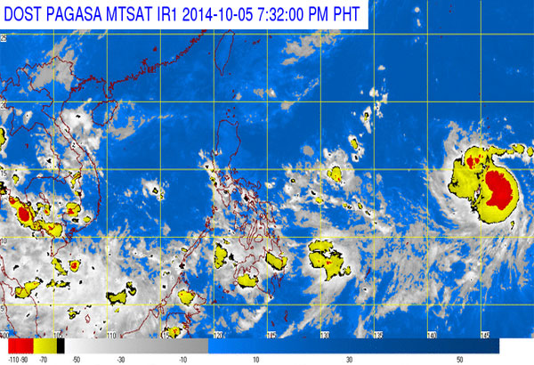
Vongfong was expected to pass through the northeastern
boundary of the country on Wednesday or Thursday, the Philippine Atmospheric,
Geophysical and Astronomical Services Administration (PAGASA) said yesterday.
Vongfong will be locally named Ompong once it enters the
Philippine
area of responsibility, PAGASA said.
area of responsibility, PAGASA said.
It said Vongfong may follow the track of Typhoon Neneng
(Phanfone), which exited the country on Saturday.
“If it maintains its current track of west-northwest, it may
enter the Philippine area of responsibility by Wednesday or Thursday,” PAGASA
weather forecaster Fernando Cada said.
The weather bureau said that light to moderate rains may
affect the eastern section of Luzon, Palawan and the Visayas on Wednesday due
to the trough of the typhoon.
The rest of the country will have partly cloudy to cloudy
skies apart from rainshowers or thunderstorms, it added.
PAGASA said the tropical cyclone was forecast to move toward
the southern islands of Japan.
“It is not expected to make landfall in any part of the
country,” the weather bureau said.
Meanwhile, PAGASA said the intertropical convergence zone
will continue to bring cloudy skies with light to moderate rainshowers and
thunderstorms over the Visayas, Bicol region, Caraga and the provinces of
Mindoro until today.
Metro Manila and the rest of the country will be partly
cloudy to cloudy with isolated rainshowers or thunderstorms.
PAGASA said the coastal waters of Northern Luzon will be
moderate to rough in the next 24 hours.
Source: www.philstar.com
No comments:
Post a Comment